
What Is a Topographic Survey?
REtipster features products and services we find useful. If you buy something through the links below, we may receive a referral fee, which helps support our work. Learn more.


What Is a Topographic Survey For?
A topographic survey (or “topo survey” for short) is an organized compilation of data showing the natural and man-made terrain features of the land. A topographic survey will show a parcel of land’s position, location, and elevation and will reveal permanent features like hills, woodland, rivers, and other structures that would otherwise not be listed on traditional maps and surveys. Cross-referencing topographic maps can also show the history of elevation changes in a given area[1].
A topographic survey helps architects, civil engineers, and other professionals in real estate development to visualize the land’s physical features and assist them in designing a tract of land for development. Topographic surveys are most commonly used when planning new construction, remodeling, utility improvements, or right-of-way acquisition[2].
How Accurate Is a Topographic Survey?
The United States Geological Survey (USGS) produces topographic maps, with an accuracy of within 20 feet (6 meters) or less[3]. While this is considered very good, these are not good enough for any kind of regulation, making them appropriate for general reference only.

Private enterprises that use high-quality surveying equipment, however, follow international accuracy standards[4] of 3 feet (1 meter) in urban areas or 8 feet (2.5 meters) in rural areas; even newer methods produce an accuracy of better than 20 inches (50 centimeters). In general, accuracies like these are useful for regulation or legal matters.
Different Types of Topographic Surveys
A topographic survey is a type of a land survey[5], which is ordered to identify property boundary lines before development and construction. However, there are also other types of topographic surveys.
- Wetlands Delineation – this is an assessment done on a property to determine the presence and location of wetlands on-site, such as a swamp, bog, or fen. Defining a “wetland” may vary from state to state, although the official definition is that these are areas flooded or saturated with water for more than three consecutive weeks during the growing season[6]. When a property has lower topography with wet areas, this often has a direct correlation to the presence of wetlands.
- Geodetic Survey – a geodetic survey is strictly defined as measuring and determining certain points on the Earth’s surface by accounting for the planet’s shape, curvature, and size of the planet. Geodetic surveys use marks or monuments on strategic areas around the Earth calibrated by a constellation of satellites in low Earth orbit. Typically, geodetic surveys use remote sensing to map out shorelines and coasts, providing imagery for specific uses such as disaster mitigation[7].
- Hydrographic Survey – a hydrographic survey maps out bodies of water, particularly the oceans. A similar discipline is a bathymetric survey, a topographic survey for the ocean floor.
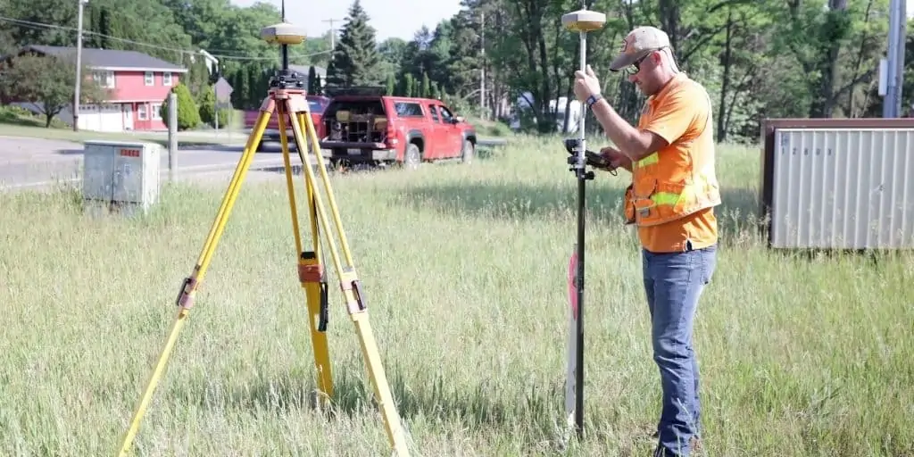
How Are Topographic Surveys Created?
Topographic surveys generally use two main systems: electronic distance measurement (EDM) and a satellite-based system, either through the global positioning system (GPS) or the global navigation satellite system (GNSS), or a combination of both.
These methods have largely superseded outdated practices, such as triangulation and calculating coordinates using pre-known markers or monuments. In cases where the land surveyor has no access to more accurate equipment, their topographic data is verified by GNSS recalculation, often to convert data to a more standard, internationally readable model like the World Geodetic System (WGS)[8].
Topographic maps are usually in 2D or 3D formats that can be manipulated in computer-assisted design (CAD) software.
Steps Involved in a Topographic Survey
Typically, there are six steps when carrying out a topographic survey meant for real estate development purposes.
- Assessment – the surveyor assesses the site and the geographic extent of the survey, including the level of accuracy, detail, and the output format depending on the purpose of the survey.
- Scheduling – the surveyor confers with the client (such as an investor or developer) to determine when the survey will take place.
- Data collection – the surveyor takes physical measurements from many different points on the subject property.
- Processing – the data is filtered, sorted, and arranged in a way that the surveyor and the client can understand the locations of all the contour lines throughout the property.
- Quality control – the output is inspected, and depending on the level of accuracy required, may need more than one set of human eyes to validate the data.
- Survey delivery – the surveyor submits the map to the client in the output format that was requested. Print-outs are common, which can be used for paperwork.
How to Read a Topographic Map
Topographic maps are two-dimensional representations of the elevations and contour lines of the land, which are in three dimensions. To show relative elevation, distance, and positions of landforms, topographic maps extensively use symbols that may include color-coding.
Contour Lines
Contour lines are the main feature of a topographic map. These are lines that show the elevation of a particular landform in feet or meters (in the U.S., in feet is more common). In general, the closer they are together, the steeper the elevation; the farther they are, the more gradual the rise and fall of the slope.
There is also a contour line shaded darker than regular contour lines, called “index lines.” They have this name because they are reference points for elevation. These lines have a number on them, which is the elevation of that index line all along its length. This allows someone to see the “direction” of the elevation.
Most topographic maps contain a “contour interval” indication, such as “contour interval 60 feet.” This means that the spacing of the contour lines denote the real-world distance between two lines of a contour is 60 feet. When landforms are shorter than the contour interval, they will not show up in a contour map but will instead show up as a flat area.
Landforms
Contour lines can also describe landforms, depending on their shape, direction, and how close they are together. For example, a canyon or gully is represented by V- or U-shaped contour lines on the topographic map, while a pass or a saddle looks like an hourglass shape.
In a topographic map, peaks will have gradually smaller and smaller contour lines that end in a roughly circular shape. The highest point will be marked with an “X,” with its elevation indicated beside it.
Orientation and Scale
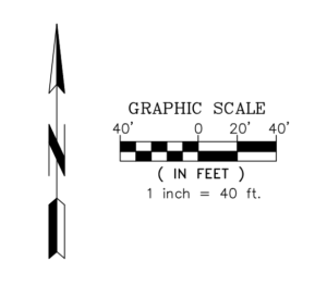 Like all maps, topographic maps have a scale that represents the real-world distance between objects. Depending on the resolution (or how big and detailed the map is), these scales will vary and may have different units such as miles, kilometers, feet to inches, centimeters, or millimeters.
Most topographic maps are also oriented so that true north is at the top of the page of a printed map[9].
Other Symbols
A topographic map may also have other symbols that are standard across many map products. The USGS has an exhaustive list of these symbols, which have been in use for over a hundred years[10].
Here are major symbols that may appear in a typical topographic map:
- Black lines – short dash lines are trails; double short dash lines are dirt roads. Alternating short and long dash lines are boundaries.
- Red lines – survey lines or city, township, or municipality boundaries.
- Blue lines – streams or rivers; roughly circular blue areas are enclosed bodies of water (such as ponds, lagoons, lakes, etc.)
- Green areas – wooded areas consisting of tall vegetation (i.e., trees).
- Light gray areas – cities or densely populated areas (in some maps may appear pink).
- White areas – mostly flat land but may also contain short vegetation.
Takeaways
A topographic survey is a type of land survey that emphasizes the natural or structural features of terrain, particularly its relative elevation and depth. In real estate, topographic surveys are ordered to better understand a certain piece of land, including its boundary lines and the general physical features of the area.
Reading a topographic map generally revolves around understanding contour lines—brown lines that denote elevation and the shape of the landform. Topographic maps also show other features, such as trails, roads, bodies of water, urban areas, and boundaries, making them useful for other disciplines, including engineering and construction.
Sources
- Florida Museum. (n.d.) How to Use Topographic Maps. Retrieved from https://www.floridamuseum.ufl.edu/invertpaleo/resources/topographic-maps/
- Partner ESI. (n.d.) Topographic Services. Retrieved from https://www.partneresi.com/services/land-surveying-mapping/topographic-surveys
- United States Geological Survey. (n.d.) How accurate are US Topo maps, and why don’t they have an accuracy statement? Retrieved from https://www.usgs.gov/faqs/how-accurate-are-us-topo-maps-and-why-dont-they-have-accuracy-statement
- International Standards Consultations. (2018.) Appendix B – Topographic Survey Detail Accuracy Banding Table. International Land Measurement Standards (ILMS). Retrieved from https://consultations.intstandards.org/connect.ti/ilms/viewCompoundDoc?docid=9976084&partId=9979316&sessionid=&voteid=
- Vandenboss, K. (2020.) What Is a Land Survey, and When Do You Need One? Millionacres. Retrieved from https://www.millionacres.com/real-estate-investing/what-is-a-land-survey-and-when-do-you-need-one/
- Tiner, R. (1991.) How Wet is a Wetland? U.S. Fish & Wildlife Service. Retrieved from https://www.fws.gov/northeast/ecologicalservices/pdf/102_how_wet_is_a_wetland.pdf
- National Geodetic Survey. (n.d.) Remote Sensing Information. National Oceanic and Atmospheric Administration. Retrieved from https://geodesy.noaa.gov/INFO/remote-sensing.shtml
- Cranes and Machinery. (n.d.) Types of Topographical Survey. Retrieved from https://www.gruasyaparejos.com/en/topography/types-of-topographical-survey/
- Harris, D., & Tefend. (2019). Map Orientation and Scale. Retrieved from https://geo.libretexts.org/@go/page/5469
- TopoZone. (n.d.) Topographic Map Legend and Symbols. Retrieved from https://www.topozone.com/topographic-map-legend-symbols/
