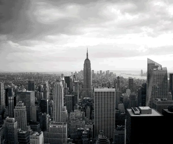


Have you ever found yourself scrolling through property listings, only to be captivated by those breathtaking aerial shots that give a bird's-eye view of the entire property?
Or perhaps you've been on the fence about purchasing a piece of land, wishing you could get a comprehensive look at its layout and surroundings before deciding. Wouldn't it be helpful to see what it looks like from the sky?
![]() Enter Droners.io, a game-changer in real estate visuals. This online marketplace is your one-stop shop to find and hire skilled drone pilots who can capture stunning photos and videos of properties across the US.
Enter Droners.io, a game-changer in real estate visuals. This online marketplace is your one-stop shop to find and hire skilled drone pilots who can capture stunning photos and videos of properties across the US.
Whether you're looking to drastically improve your property listings or want an extra set of “eyes in the sky” for your due diligence process, Droners.io can help! Dive in with me as we explore how this platform can be a land investor's best friend!
Why Drone Footage?
In the world of land investing, presentation is everything.
While ground-level photos can capture the essence of a property, drone footage can give your properties a unique and visually stunning perspective that can elevate your listing above the other noise in your market.
Imagine showcasing a vast expanse of land from a bird's-eye view, highlighting its topography, neighboring properties, surrounding area, and other unique features.
Sure, anyone can snap a picture of a dense forest or an open plain, and sometimes this is enough (I've sold hundreds of properties this way). But when we're talking about LAND, a type of property many buyers will pay arbitrarily high prices for based on its presentation, isn't it worth a few hundred extra bucks if your property can sell faster or at a higher price (or both) with the added allure of drone imagery?
How to Get Drone Footage?
Do you need to buy your own drone and drive out to your own properties to get these pictures yourself?
I suppose you could. But in most cases, even if you own a drone, you can save a ton of time and money by hiring a local, commercially licensed drone pilot to get these pictures for you.
You can find skilled drone pilots on numerous platforms. Droners.io is the one I hear of most often, but there are others, like Thumbtack, Bark, and Craigslist, where you can find these professionals as well.
What Instructions Should You Provide?
When hiring a drone pilot, clarity is key. Here are some pointers on what you might need to specify:
- Type and duration of footage (video, photos, or both).
- Editing requirements (music, subtitles, etc.).
- Desired quality (4K, 1080p, etc.).
- The exact address or coordinates for airspace restrictions check.
- Preferred timeframe or specific time of day.
For a detailed example of how to provide instructions, you can download an example right here!
Done-For-You Drone Service
If you've ever been overwhelmed trying to manage a drone shoot, from hiring a pilot, coordinating the logistics, to editing raw footage, Droners.io now offers something that's going to make your life a lot easier.
They’ve launched a Done-For-You drone service specifically tailored for real estate investors, especially land flippers. No more job boards, no bidding wars, no guesswork. You place the order, and they take care of everything, from shoot coordination to final edits and parcel overlays.
Here's a quick video explaining exactly how this service works and why it's such a valuable time-saver for land investors like us.
Try Droners Done-For-You Service!
If you're constantly juggling deals, listings, and due diligence tasks, this is one of those services that can quietly become an essential part of your process, freeing you up to focus on what matters most.
How Much Does It Cost?
The cost of drone footage varies based on the pilot's expertise, location, and specific requirements. Typically, pilots charge between $75 to $150/hr.
When I buy drone footage like this, I plan on spending at least $300 for the job.
There is usually an additional cost if you require additional editing, such as music or subtitles.
Basic packages might start as low as $100 on platforms like Droners, but you'll usually be paying $200 to $300 (even higher) for more involved projects.
When Should You Get Drone Footage?
The best time to get drone footage is after you get a signed contract from the seller but before closing the deal.
This timing allows you to use the footage for due diligence and when you create your property listing to sell.
While your property might look perfect from a satellite map, satellite pictures usually are not up-to-date. You could be looking at pictures from years ago, which tells you little about what the property looks like today.
Likewise, even if you hire a local photographer who takes pictures from the ground, these photos won't always show you what the neighboring properties look like, and that's where drone photography shines.
By ordering drone videos and photos during the due diligence phase, you'll be equipped with all the information you need and ready to market the property immediately after you purchase it!
Tricks of the Trade
Identifying your exact property boundaries in drone footage can be tricky, especially if the property is landlocked or lacks clear boundary lines in the nearby landscape.
To help potential buyers, consider asking your drone pilot to edit your video to include parcel lines or point out landmarks on your subject property.
While some drone photographers offer this as an added service, you can do it yourself using Google Earth and include this as an image or a supplement in your video. I'll explain how this works in this video:
This added touch enhances the viewer's experience and clarifies the property's dimensions and boundaries.
RELATED: 10 Google Earth Hacks Every Real Estate Investor Should Know
Conclusion
While drone photography isn't a strict necessity for every land deal, it's hard to deny this is a valuable visual asset that can significantly enhance your property's appeal to buyers. Not to mention, it can inform you about the property before you buy it!
Whether you're using it for due diligence or to sell your properties faster, the bird's-eye view from a drone offers a unique perspective that ground-level photos just cannot match.