REtipster does not provide legal advice. The information in this article can be impacted by many unique variables. Always consult with a qualified legal professional before taking action.
One of the most critical (and confusing) pieces of information that goes into a land transaction is the legal description.
To put it simply, a property's legal description is the definition of the real estate being bought and sold. It's more authoritative than the address and the parcel number, and if this information is stated incorrectly on a deed, the wrong piece of real estate will be transferred.
The legal description (and in some cases, the municipal plat maps it references) allow us to determine the size, shape, boundaries, and location of a parcel. This is why legal descriptions are required on every deed, and why land surveyors need this information in order to do their job.
Even with the inherent importance of a property's legal description, I've found that most real estate investors have no idea how to comprehend or interpret this bizarre string of letters and numbers. They just copy and paste it from one document to another, with no appreciation for what it means, why it's important, and why accuracy is crucial.
For a long time now, I've intended to write a detailed blog post explaining the basics of how legal descriptions work and why they're important. However, earlier this year I stumbled across this book and noticed a section that gave a great primer on the subject. Since this book nailed it with such precision, I invited the author to share this segment of his book right here on the REtipster Blog.
Side Note: Some legal descriptions are VERY complicated and require an experienced eye to fully ‘decode' the information. This article won't make you an expert overnight, but I think you'll see how it's a helpful introduction that offers some clarity to a fairly confusing subject.
When Thomas Jefferson woke up on May 3rd, 1803, the day after finalizing his famous “Louisiana Purchase,” there must have been a moment where he looked at himself in the mirror and thought,
“Louisiana Purchase? What exactly did I just buy?!”

Thankfully, the monumental effort by the U.S. government to establish survey grids – townships – had already begun by then, years earlier in fact.
The results have lasted through the decades, and are still very useful for those engaged in real estate today. Almost all of the country is divided into these six-mile-square boxes.
There are some interesting exceptions, however. Texas, once an independent country, is mostly divided into ‘surveys’ which are based on old Spanish land grants. In the Lone Star State, a legal description starts at a designated point of the survey (the Point of Beginning or POB) and runs as a “metes-and-bounds” description from there.
But for most of us outside of Texas, the Township System (‘PLSS’ or Public Land Survey System), is where it’s at. An understanding of the Township system is essential for any land man (or woman), and will put you light years ahead of the competition when it comes to locating land.
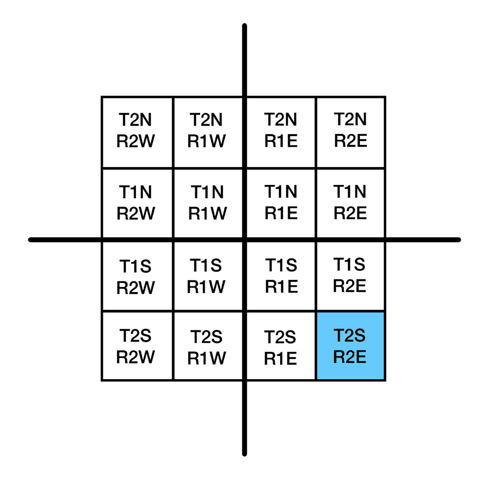
To identify a specific township (a specific box six miles wide and six miles tall) – states have an east-west axis and a north-south axis drawn through their middle. It’s like a Cartesian graph.
So a certain township may be 2 miles south of that state’s parallel line and 2 miles east of the vertical line. That’s where townships get their names. Let’s check out an example:
The township in this example would be called: ‘Township 2 South, Range 2 East (T2S-R2E).”
(As we explain this, you might want to check out some real-world examples. Check out El Paso County Colorado for a particularly square, and thus straightforward illustration.)
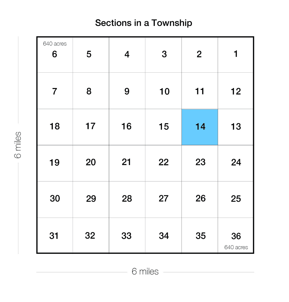
Remember: Each township is six miles wide by six miles tall.
This means that a township contains 36 square miles.
The square miles are called sections.
The sections are numbered, usually starting with #1 at the NE corner and snaking through the township to end with #36 at the SE corner.
One section (a square mile) is 5,280’ X 5,280’ and contains 640 acres. This is a perfect section, which most aren’t.
So once the township is identified, we name our section within the township. Let’s say our property is in Section 14 (as shown in the image above).
Now we are studying Section 14, Township 2 South, Range 2 East (which can also be abbreviated as: S14, T2S-R2E).
We’ve identified a particular 640-acre tract of land.
The surveyor can start at a point in this section and run a metes-and-bounds description to identify your 20.02 acres.
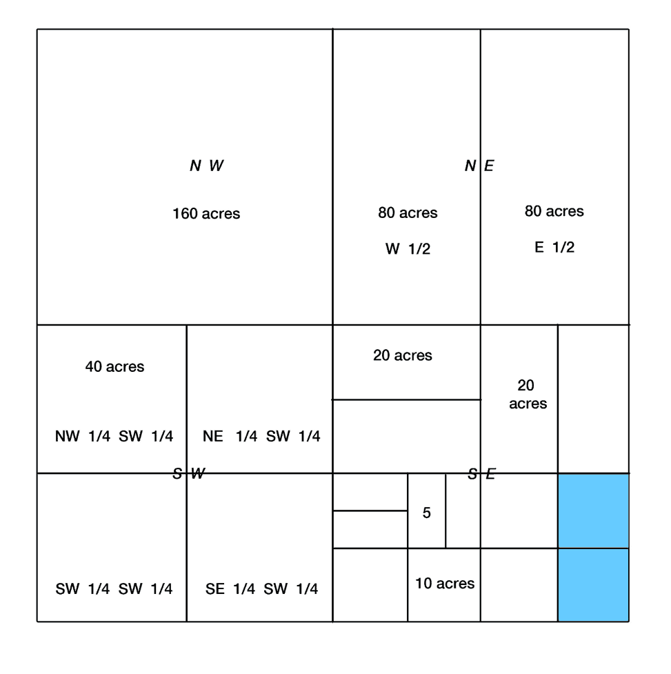
OR: He can describe a tract of land by dividing the section into fractions.
The ‘north half’ (N/2) is the north 320 acres. The ‘northwest quarter’ (NW/4) is the northwest 160 acres. The ‘northwest quarter of the northwest quarter’ (NW/4 of NW4) is the 40 acres in the extreme NW of the section.
This is why 40 acres is such a common size for land in the U.S. A section of land has 16 blocks of 40-acre tracts.
Legal descriptions using the S-T-R (Section-Township-Range) system have to be read backward. If you do that, you’ll be fed the info like this:
State, County, Township, Section, Fraction of Section, Fraction of that Fraction.
So you might buy 20 acres described as:
‘the E/2 of the SE/4 of the SE/4 of Section 14, Township 2 South, Range 2 East, Madison County, Utah.’
Start by reading it backward:
Utah
Madison County
T2S-R2E
Sec.14
SE/4 (of said Section 14)
SE/4 (of said SE/4 of said Section 14)
E/2 (of said SE/4 of said SE/4 of said Section 14)
Don’t despair. You don’t need to learn all of this right now. You can learn it as you go along, as you try to find individual properties.
You can also get the S-T-R grid added on to Google Earth for a minimal fee. Check out Earthpoint. It’s worth it. You’ll see the grid system superimposed over the aerial photos.
Play with it. Try to find the legal description for your own home.
How to Find a Property's Legal Description
If you're looking for your property's existing legal description, one way to find it is by looking at the most recent transfer deed. This document can be found in the county's records or it can be retrieved through a data service like DataTree, as explained below.
You can see in which areas of the country this data is available through DataTree's GeoCoverage map.
Anyway, I didn't tell you all this stuff just to make your head spin. Knowledge of the Section-Township-Range System is useful when we are searching for land-flip deals in the Assessor’s office, or even correctly identifying Old Man Brown’s 40-acre plot that his son is advertising on Facebook dirt cheap (but doesn’t have a plat for).
All in all, a solid knowledge of this system will have you able to plot properties while the competition is still scratching their heads.
If you enjoyed this, and are hungry for more land tips, check out E.B. Farmer’s book on land flipping, his blog, and his comprehensive e-course (be sure to use discount code ‘RETIPSTER' at checkout for some quick savings).
Image Sources: Mari Helin-Tuominen, Wikipedia


