
REtipster does not provide legal advice. The information in this article can be impacted by many unique variables. Always consult with a qualified legal professional before taking action.


If you're a land investor, you may have considered the possibilities and profit potential of subdividing land.
And if you're like most land investors, you probably have questions about the costs, timeline, and overall process.
You might even be worried it’s too complicated and confusing.
Don’t be confused or discouraged.
I used to feel this way, too, but after diving head-first and doing 50 subdivisions over the past five years, I've learned a lot about how it works, how to find the best opportunities, and how to avoid the biggest pitfalls in this unique niche.
In this guide, I will outline the entire process so you’re ready to complete a subdivision in a timely, predictable, and cost-effective way. Once you understand how to purchase the correct property, with proper planning and following a proven process, you'll be ready to tackle your first (or next) subdivision project head-on!
What’s So Great About Subdividing Land?
What is subdividing? At its core, this is the process of taking a piece of land and dividing it into smaller subunits.
Why subdivide land? As a land investor, this strategy allows you to convert a single (parent) parcel into two or more (child) parcels.
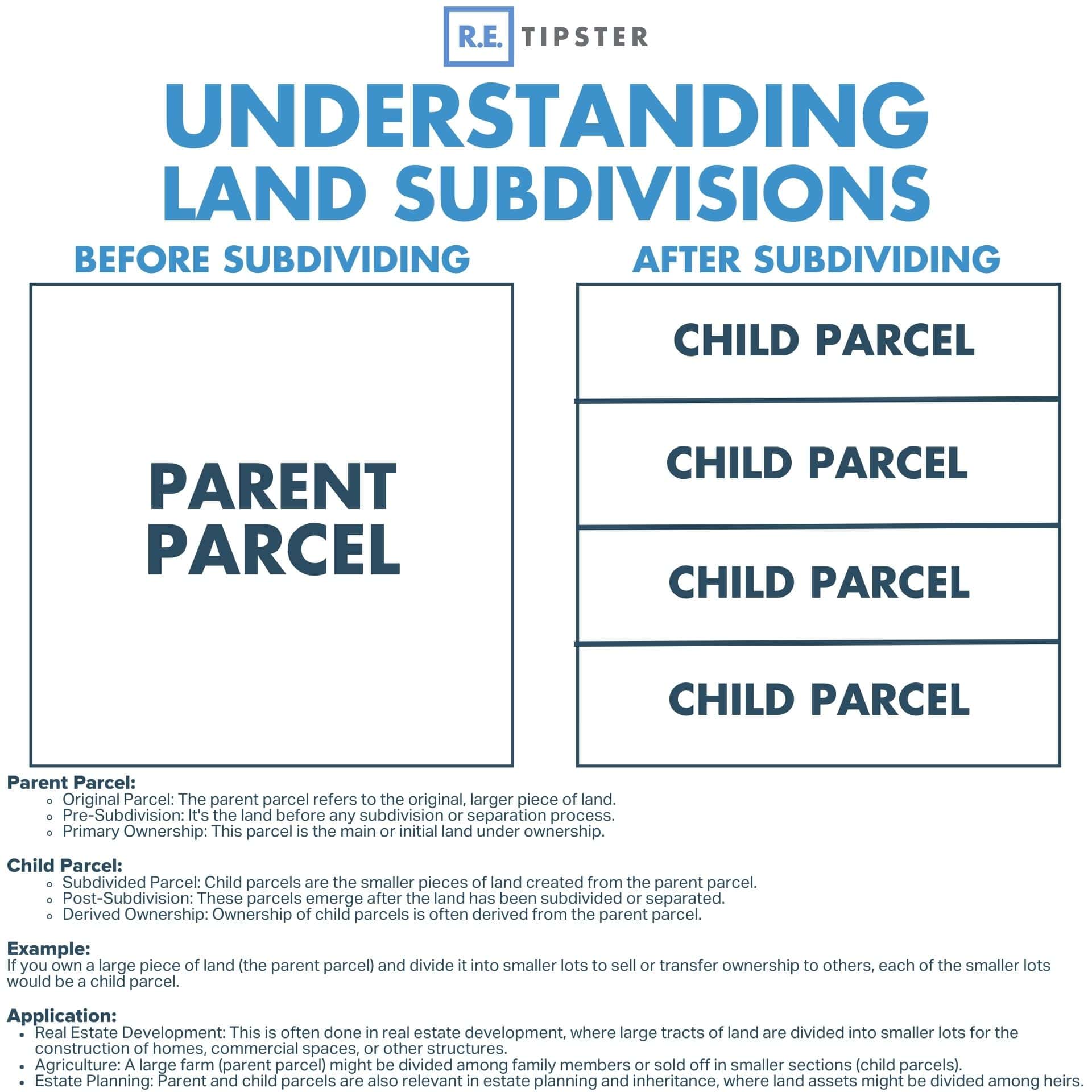
In a sense, subdividing land is one of only a few ways to create more real estate. We aren't adding more square footage to the earth but increasing the number of parcels, which creates more opportunities for more people to own real estate.
In other words, when we subdivide a large tract of land, it creates more usable and affordable parcels.
Once a parcel has been subdivided, you can sell these lots at a lower price than the original parcel but at a higher price per acre, and you can sell them off one at a time as the new buyers materialize. This reduces your cost basis in the original parcel faster and allows you to mitigate your risk in the overall investment quickly.
Forced Appreciation
Smaller parcels have a higher per-acre value than larger parcels because zoning regulations typically allow one building per lot.
For example, one family might live on a 4-acre property. On the other hand, if that same property is split into four 1-acre lots, that same land can provide homes for four families. Since more people can utilize the same property, the value also increases.
As mentioned above, each new lot is more affordable than the original large tract, which allows developers to acquire acreage at a lower price point and avoid excess land their buyers don’t need.
Risk Management
New lots are more affordable, which expands the buyer pool and accelerates sales cycles.
As a result, you can manage risk more effectively by recouping your cost basis stepwise.
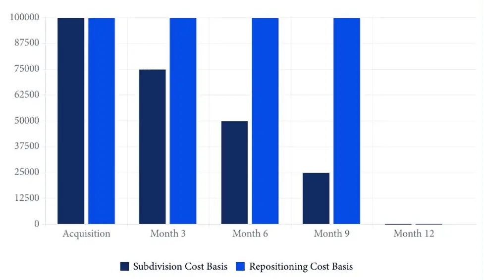
In the above chart, the dark blue represents the cost basis of a property subdivided and sold at three-month intervals (given the expanded buyer pool).
Meanwhile, the light blue bars represent the cost basis of land repositioned and sold at 12 months (without a subdivision).
Since subdivisions can be sold incrementally, they help minimize risk by reducing exposure to market events and competition.
Types of Land Subdivision
The county you’re working in likely allows for different types of subdivisions depending on a few factors, including how many new parcels you want to create.
You’ll want to pick one of the three subdivision processes that most closely match your goals for the property:
- Subdivision without county approval
- Major subdivision
- Minor subdivision
Subdivision Without County Approval
Subdivisions without county approval can save time and money. However, the drawback is that they’re only available in limited use cases. For example:
- It may only be available in certain counties.
- You can’t create too many new parcels (typically two to four parcels only).
- All new parcels must meet a minimum acreage requirement (typically 10 to 36 acres).
RELATED: How Much Land Is Needed to Build?
Major Subdivision
The benefit of major subdivisions is that the developer can create hundreds of new parcels at once if the development is approved.
The drawback is that it’s usually a lengthy, costly, and riskier process compared to its alternatives.
A major subdivision is expensive from an engineering standpoint. It requires thorough environmental studies, such as a Phase I ESA, and traffic studies. It also typically requires the developer to make significant infrastructure improvements to the land, such as power, sewer, water, and roads.
In addition, it involves multiple public hearings and county board approval, which can be contentious.
Minor Subdivision
A minor subdivision is the sweet spot between a subdivision without county approval and a major subdivision.
Minor subdivisions allow subdividers to create value without the overly restrictive requirements from the municipality, without requiring lots of money for infrastructure improvements, and without significant risk.
Many counties will allow you to subdivide your property into five or fewer properties so long as each proposed parcel fits its existing zoning designation and is accessible.
Here are some examples of when county approval would not be needed:
- 160-Acre Parent Parcel: Subdivided into three (3) 40-acre parcels and two (2) 20-acre parcels. No county approval would be needed because all are over 10 acres (zoning must support 20-acre parcels).
- 40-Acre Parent Parcel: Subdivided into four (4) 10-acre parcels. No county approval would be needed since all are above 10 acres (zoning must support 10-acre parcels).
- 40-Acre Parent Parcel: Subdivided into one (1) 20-acre parcel and four (4) 5-acre parcels. County application and approval would be needed since at least one lot is under 10 acres (zoning must support 5-acre parcels).
- 5-Acre Parent Parcel: Subdivided into five (5) 1-acre parcels. County application and approval would be needed since at least one lot is under 10 acres (zoning must support 1-acre parcels).
However, there are some situations where it can get weird. I've also seen the following:
- People have taken 10-acre properties (zoned for a minimum of 4 acres) and split them into five (5) 2-acre parcels. However, folks who attempt to get a building permit for these child parcels (no longer according to their zoning designation) are unsuccessful.
How Much Does It Cost to Subdivide Land?
Three main costs are associated with subdividing your property:
- Surveying
- Applying for a minor land division permit
- Recording the new deed
Surveying costs vary widely and largely depend on the remoteness of your property.
To get started with a surveyor, you'll need to send them the APN of your parcel to get a quote for their work.
For rural properties, the cost will be higher if your property is isolated and only accessible by four-wheel drive. This is due to the time and travel expenses your surveyor will incur.
If adjoining properties have been surveyed, this can save you money because when neighboring properties have recorded documents and survey markers, it’s easier to identify your property, saving your surveyor time.
In my experience, it's generally $1,500 to $4,000 for survey costs, depending on how remote the property is and the state of surveyed properties in the area.
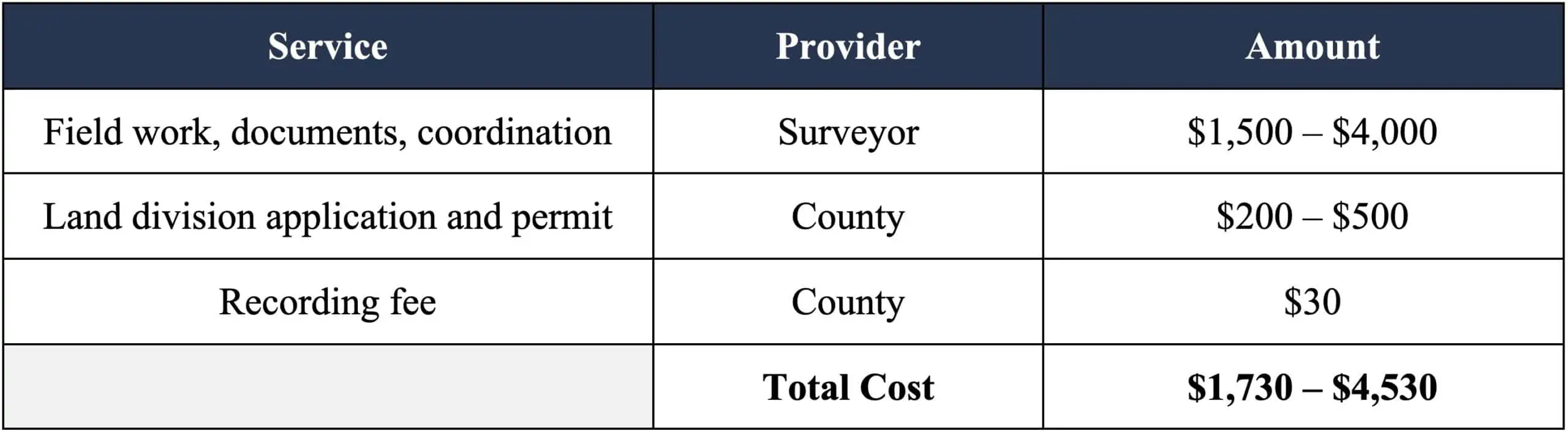
After the survey is complete and the surveyor has laid out the new parcels, the next step is applying to the county for your minor land division permit.
The county charges a processing fee and a per-parcel fee for the application. A common fee structure is around $100 per new property. For example:
- Two new parcels would be $200.
- Five new parcels would be $500.
In the final step, you'll need to record the new deed, which will list the new legal descriptions for each of the new parcels you created, listing you as the owner of each child parcel.
You pay the county recording fee to make your deed official. This is typically around $30.
How Much Time Does It Take to Subdivide Land?
In the markets where I work, a minor land division takes about four to six months to complete. The general workflow looks like this:

Timeline of a typical subdivision process
Here’s a step-by-step explanation of the timeline.
Survey
The first step is getting your land surveyed and receiving the plat map and legal descriptions to be included in your minor land division application.
Lead times for good surveyors are typically about six weeks out, and you should add in another two weeks for plat maps and legal descriptions. Eight weeks is a good estimate for your surveyor to complete all the fieldwork and produce the necessary documents.
Application
Next, the county development department will review your minor land division application.
The process varies from county to county, and jurisdictions with better staffing and resources can have your response back within a couple of weeks.
On the other hand, some rural counties don’t have adequate staff in the development office. In these cases, a county process can stretch to 30 days. In practice, you’ll submit your minor land division application, wait 30 days, and then have it automatically approved (since no one can review it).
County Recording
Once the county approves your request, you’ll need to record your new parcels with the county. This takes anywhere from a day to two weeks, depending on the speed of the county and if you submit documents electronically or by mail.
Cartography
Finally, you’ll want your new parcels to appear in the county’s mapping systems.
To do so, you can send your recorded documents to the cartography division of the county and let them know you have a new minor land division that’s been approved and recorded.
Alternatively, you can skip this process altogether. The county recorder sends over batches of new documents to cartography every few weeks, so at worst, there will be an extra month of lag time getting your new parcels in the mapping software.
Cartography has the most varied timelines among counties since the staffing varies widely. You can expect this to take anywhere from two weeks to many months, with four weeks being the average.
What If the Property Isn't Zoned Correctly?
If the property doesn’t have the correct zoning, there are still things you can try. Counties allow landowners to request rezoning for their properties, which involves the zoning commission's approval and may require county board hearings.
If this is the route you’re considering, factor in the additional process, timeline, costs, and risk you’ll be assuming.
Buy the Right Property
Your plans to subdivide a property should ideally begin when purchasing your land. This allows you to pick the parcel with the right zoning and property owners' association regulations to help the process go smoothly.
Zoning Considerations
When you buy land, you'll want to ensure it has the correct zoning for what you (or your future buyer) want it to be. County zoning determines what can be built on your property and how it can be used, whether it's mobile homes, temporary or permanent RV usage, tiny homes, commercial uses, or single-family residences.
For instance, you might see a 10-acre property zoned Rural-10, meaning the county has zoned it as a rural property that needs a minimum of 10 acres. If you buy this property, you wouldn’t have an opportunity to split it since none of the new parcels would meet the minimum of 10 acres.
On the other hand, if you buy a 10-acre property zoned Rural-2 (meaning it’s a rural property with a minimum of 2 acres), this zoning classification would allow you to split it into five 2-acre properties. This type of subdivision would likely be approved, given the county allows for five new parcels within their minor land division process.
Also, remember that you could just as well do something different. If it’s advantageous or based on topography, you might split the land into 2-acre and 8-acre parcels. In this case, you would technically still comply with the minimum acreage and maximum number of new parcel requirements.
Covenants, Conditions and Restrictions
If there’s a Property Owners Association or Homeowners Association for the property, make sure the Covenants, Conditions, and Restrictions (CC&Rs) allow for parcel splits.
In addition, check if the CC&Rs further restrict the number of new child parcels or the minimum size of new parcels.
Lastly, ensure you understand the additional costs for new parcels from the Property Owners Association. It’s typical for associations to charge additional fees for each new parcel to cover their administrative and accounting costs.
Find the Right Surveyor
The most important step in beginning the minor land division process is hiring the right surveyor.
Your surveyor will be your point of contact with the county, and they will act as your advocate for completing your minor land division. They will have connections with people in planning and zoning, the development department that reviews your application, and the personnel in cartography who map parcels in the county system.
Getting the right surveyor is important, especially in a rural community. Finding someone who has worked in the county for several years and has built strong ties and relationships will go a long way. Look for someone who is responsive, detail-oriented, and excels at communicating.
We recommend calling or emailing several different surveyors in your county of interest. Be sure to get on the phone to discuss their process and how minor land divisions work in the county.
You might not find the right surveyor on your first, second, or third call. If you aren't impressed with the first person you find, keep looking until you find the right person because this role matters a lot!
Evaluate your potential surveyor based on these aspects:
- Were they available on time for your phone meeting?
- Were they able to communicate all the details of the land division process?
- Were they able to answer your questions and help you understand what you need to know?
- Did you get a sense that they have deep community ties and relationships in the county?
Here are a few of the questions we typically ask:
- Can you explain the minor land division process in this county?
- How long does the process take?
- How much does it cost?
- How can we effectively work together, given that we’re not local to the area (if that’s the case for you)?
- Are there any peculiarities with certain towns in the county?
- Is there anything else I should know or mistakes I should avoid in this county?
When you've decided on the best surveyor for the job, send over the property information for a quote!
Plan Your Subdivision
To get a quote for the survey work on your subdivision, your surveyor will need at least three key pieces of information:
- The parcel number of your property.
- The existing recorded deed with the legal description.
- A sketch of how you’d like to subdivide your land.
Your surveyor will use the APN number and deed to verify property ownership and look up its location.
Sketch out your plan for the subdivision by pulling up a map of your property in the county’s geographic information system (GIS). Then, do a rough sketch of what you’d like to accomplish. It needs to be well thought out, but the sketch itself doesn’t need to be fancy.
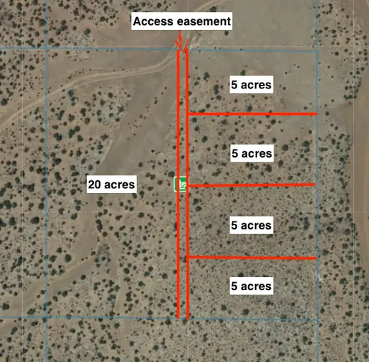
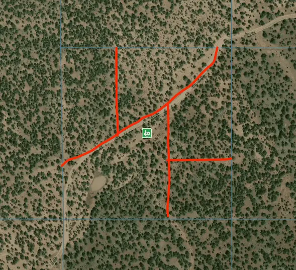
For example, here’s a real sketch we sent a surveyor to break a 40-acre parcel into five separate lots with an access easement down the middle:
When completing your sketch, consider the terrain of your property and any other land features you may need to work around to ensure all new parcels are usable.
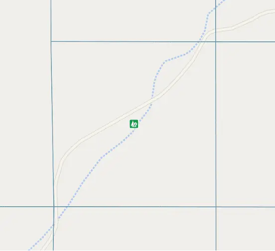
For example, here’s a different property we split that required looking more closely at the terrain. I'll include two views using different map layers, but they’re the same property.
The first map shows the road and the seasonal creek (wash) across the property. In the second map (with a satellite imagery layer), you'll see the seasonal creek has created a small pond in the southwestern portion of the parcel.
In examining the satellite imagery, you can see an additional small wash running north to south.
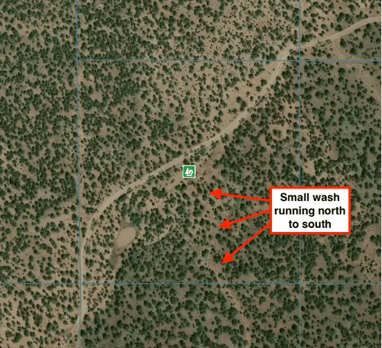
In situations like this, if you don't look closely to examine the natural features of the property, it's easy to accidentally create unusable parcels.
If we had done a split like you see below, we would have significantly reduced the value of two of the child parcels. Given the locations of the road, wash, pond, and the standard setbacks, it would leave little land to build on:
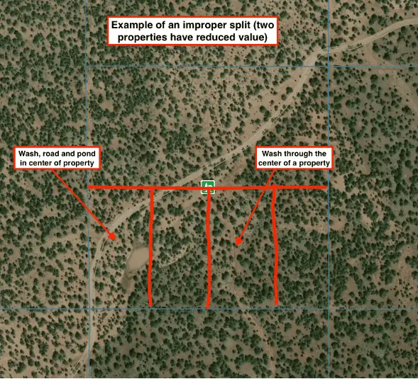
Don’t do this!
Instead, we can use the existing roads and terrain to inform our split. This way, we will have usable properties with large portions of land for building.
Try something like this instead:
Since the terrain is so important when splitting parcels, use all the data you have available, including:
- Maps from the county's GIS system.
- Topographic maps with contour lines showing elevation changes.
- Flood maps.
- Google Earth views.
A tool like Land ID can be very useful for identifying and planning around these kinds of land features.
It's important to put some effort into producing an effective plan for your surveyor. It’s well worth the time to ensure valuable parcels.
Survey Field Work, Plat Map, and Legal Descriptions
Once you have a logical subdivision plan laid out, your surveyor will begin their fieldwork by finding the corners of your property with the following:
- The legal description of your property.
- Existing surveys on record.
- Specialized surveying tools and GPS equipment.
Once the surveyor finds each corner, they’ll look for existing markers in these locations. These could be geodetic survey marks (metal disks with stamped legends on their faces), rebar pounded into the ground, or pins knocked into rocks. If they can’t find them, they’ll add new markers and annotate them on your plat map.
Next, they’ll use your sketch to place markers on the proposed corners of your subdivision. Surveyors use these new locations to produce the documents you submit to the county in your application.
Your surveyor will then head back to their office and work on producing two documents. The first is a plat map of your property showing:
- Existing property boundaries
- Existing property markers
- Existing easements and fences
- Proposed subdivision boundaries
- Proposed subdivision markers
- Proposed acreage for each parcel
It will also include new easements to ensure all properties remain legally accessible.
The result will be a plat map like this:
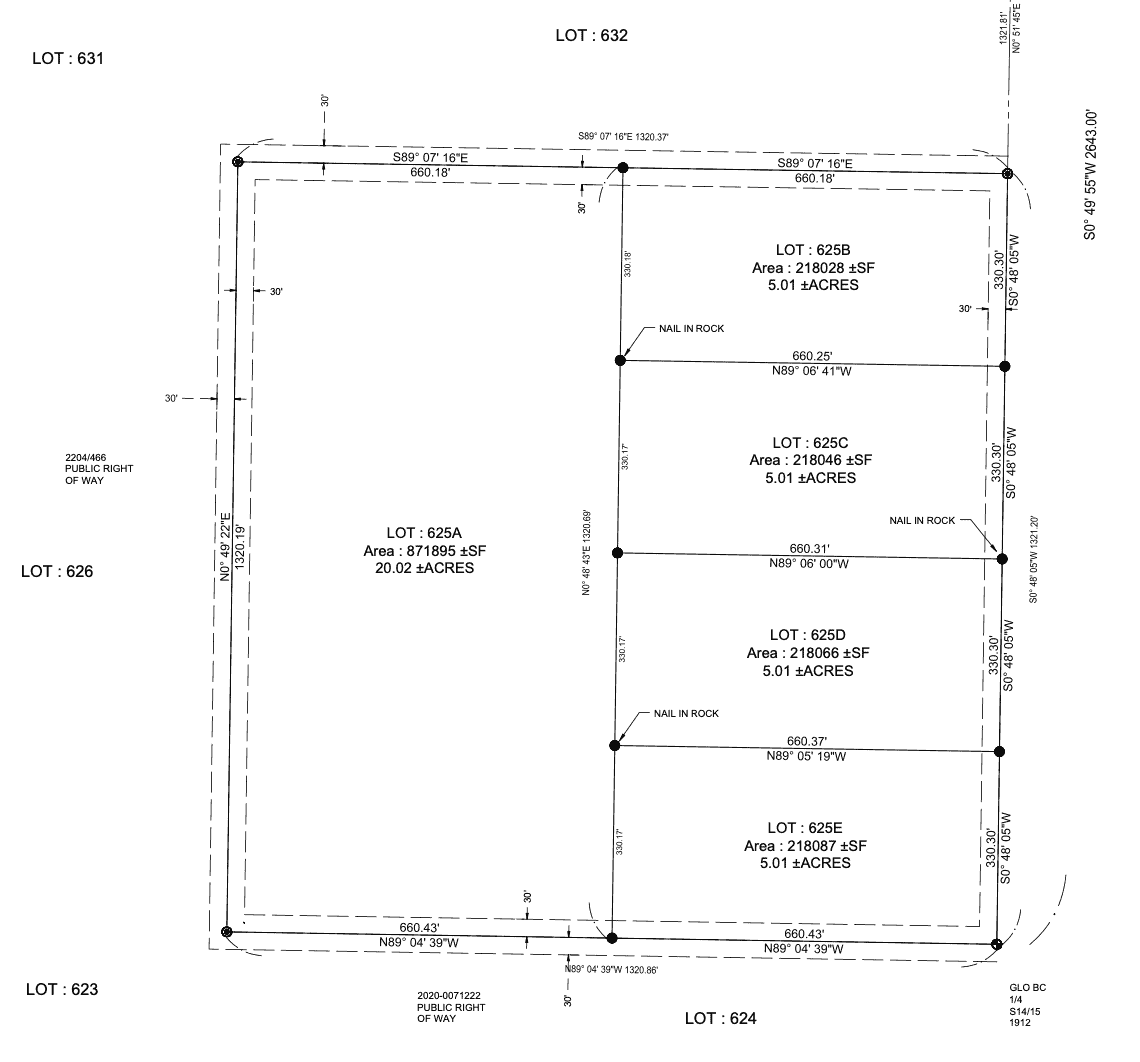
For the second document, your surveyor will produce new legal descriptions for each proposed parcel.
For example, your parent parcel might have started with a legal description like this:
The Southeast Quarter of the Northeast Quarter of Section 15, Township 24 North, Range 10 West of the Gila and Salt River Base and Meridian.
EXCEPT all mineral rights of every kind; and EXCEPT a 30 foot strip around the perimeter of the above described Parcel as and for public right of way.
And when you finish the subdivision, you could end up with five new legal descriptions, each of which looks something like this:
Lot A
A portion of Unit 1 Unrecorded also being the Southeast quarter of the Northeast quarter, Section 15, Township 24 North, Range 10 West of the Gila and Salt River Base and Meridian, described as follows:
COMMENCING at the Northeast corner of said Section, a GLO brass cap stamped 1912 from which the East ¼ corner, a GLO Brass cap stamped ¼ S14/15 1912.
Thence along the East line of Said Section 15, a 5/8” rebar with Aluminum Cap LS 5570;
Thence along the North Lline of said Parcel, 660.18 feet the POINT OF BEGINNING a ½” rebar with cap LS 53890;
Thence, South 1320.69 feet a ½” rebar with cap LS 53890.
Thence along the South line of said Parcel, 660.43 feet a 5/8” rebar with Aluminum Cap LS 5570;
Thence along the West line of said Parcel, 1320.19 feet a 5/8” rebar with Aluminum Cap LS 5570;
Thence along the North line of said Parcel, 660.18 feet to the POINT OF BEGINNING.
Said described parcel contains 871895 square feet (20.02 acres), more or less, subject to any and all easements, reservations, restrictions and conveyances of record.
Minor land divisions commonly follow a naming convention that adds a letter to the end of existing parcel numbers. So, if you start with parcel 123-45-678, your surveyor will prepare five new legal descriptions for parcels 123-45-678A through 123-45-678E.
Land Division Application With the County
Once your plat map and legal descriptions are satisfactory, ask your surveyor to begin the county’s minor land division application.
Your surveyor will complete the application package, which typically requires the following:
- Application fee.
- Legal description of the existing parcel.
- Legal descriptions of the proposed parcels, including access and utility easements.
- Documentation demonstrating legal access to the parcels.
- Statement from the surveyor attesting that there is physical access to the properties.
- Proposed plat map.
After they receive the application, the county will approve or deny your request.
If they deny your request, you can typically appeal the decision within 30 days.
If they approve your application, you will be awarded a minor land division permit.
Congratulations! You’re almost there, but you don’t have your new properties until you record the new deed.
Recording Your New Parcels
Once approved, your surveyor will record the plat map and minor land division permit on your behalf.
You’ll record a deed from yourself to yourself, referencing the existing legal description and new legal descriptions.
In most states, you’ll also be exempted from certain filing fees since you’re not selling the properties. If that’s the case in your jurisdiction, you’ll also include the exemption verbiage in the deed.
Once this document is recorded, it's official! Your subdivision is complete!
Final Steps
An optional last step is to send your recorded deed directly to the county’s cartography department. Doing this will speed up getting your new parcels into the county’s mapping system by a few weeks.
Once this is updated, people will see the new parcels when looking up property in the county GIS (and third-party data systems that pull from the county’s mapping software).
Congratulations, you made it! You now have all the knowledge you need to buy the right land, plan your subdivision, and follow the process to its successful completion.
 Chuck Dreison serves as the Manager of Meridian Real Estate Income Fund. His knowledge of the land industry is derived from successfully completing over 200 transactions through the full real estate asset lifecycle, including acquisition, development, repositioning, and disposition. He holds a bachelor’s degree from James Madison University and a master’s degree from California State University, Los Angeles. In addition to his role as Manager of the Fund, Chuck, a former Marine, regularly mentors fellow military veterans in the real estate sector. He can be reached through www.meridianrei.com.